
Identifier
MDA.MUS.00012
Support
Structure
Title
Interactive installation Bay in Movement
Instalação interativa Baía em Movimento
Instalação interativa Baía em Movimento
Group
Description
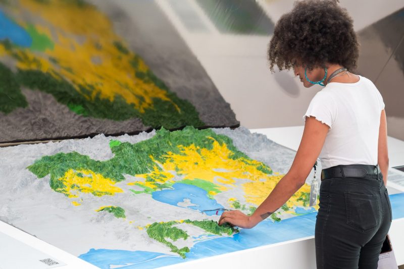
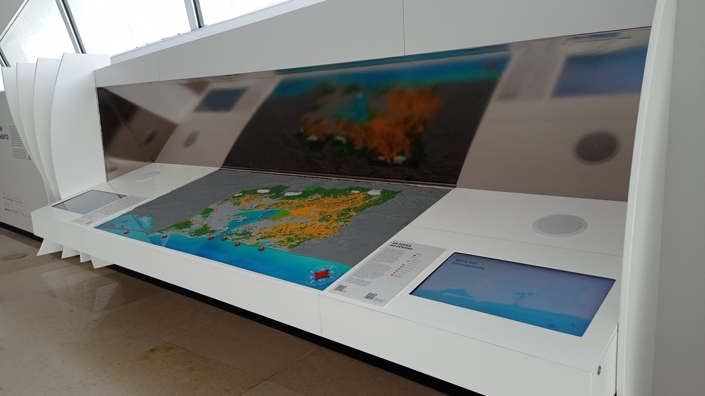
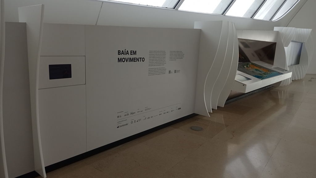
The interactive installation "Baía em Movimento" (Bay in Motion) is located in the "Belvedere" area, on the west side of the permanent exhibition. The space emphasizes the importance of bays as environments naturally favorable to life and human settlement, while also highlighting the impacts of intense and disordered occupation, which has transformed Guanabara Bay into a territory marked by serious environmental problems and successive unfulfilled promises of depollution. Before the incorporation of the model, the installation consisted only of interactive resources and was called "Baía de Todos Nós" (Bay of Us All).
The texts related to the interactive installation "Baía em Movimento" can be found in the "Other Information > Text" section.
A instalação interativa Baía em Movimento está localizada na área "Belvedere", na lateral oeste da exposição de longa duração. O espaço enfatiza a relevância das baías como ambientes naturalmente favoráveis à vida e ao assentamento humano, ao mesmo tempo em que alerta para os impactos da ocupação intensa e desordenada, que transformou a Baía de Guanabara em um território marcado por graves problemas ambientais e por sucessivas promessas de despoluição não cumpridas. Antes da incorporação da maquete, a instalação era composta apenas pelos recursos interativos e levava o nome Baía de Todos Nós. Os textos relacionados à Instalação interativa Baía em Movimento encontram-se no campo Demais informações > Texto.
A instalação interativa Baía em Movimento está localizada na área "Belvedere", na lateral oeste da exposição de longa duração. O espaço enfatiza a relevância das baías como ambientes naturalmente favoráveis à vida e ao assentamento humano, ao mesmo tempo em que alerta para os impactos da ocupação intensa e desordenada, que transformou a Baía de Guanabara em um território marcado por graves problemas ambientais e por sucessivas promessas de despoluição não cumpridas. Antes da incorporação da maquete, a instalação era composta apenas pelos recursos interativos e levava o nome Baía de Todos Nós. Os textos relacionados à Instalação interativa Baía em Movimento encontram-se no campo Demais informações > Texto.
Collection
Author
Co-author
LilliputOrganization
Caption
Instalação interativa Baía em Movimento. 2022. ≅ 200 x 1400 x 120 cm | Duração variável.
.
Interactive installation Bay in Movement. 2022. ≅ 200 x 1400 x 120 cm | Variable duration.
.
Instalación interactiva Bahía en movimiento. 2022. ≅ 200 x 1400 x 120 cm | Duración variable.
Accessibility
Additional Type
Technique
Video recordingTechnique
3D printingTechnique
Assembly | MountingTechnique
ModelingTechnique
PaintingTechnique
Electrostatic paintingTechnique
Mixed mediaTechnique
Material
Steel cableMaterial
Speaker box (Subwoofer)Material
WoodMaterial
Acrylic feltMaterial
Video monitor (LED)Material
Multi-touch monitor (LED)Material
MP4 (MPEG-4 Part 14)Material
PlasticMaterial
ResinMaterial
PaintMaterial
Epoxy paintMaterial
Size
≅ 200 x 1400 x 120 cm
fileExtension
resolution
variável
fileSize
variável
duration
variável
language
speaker
producer
researcher
Marcio Santa RosaPerson
Amarílis Lage de MacedoPerson
Anna Fornero AguiarPerson
Joana Guedes GalettiPerson
Event
Project
Text
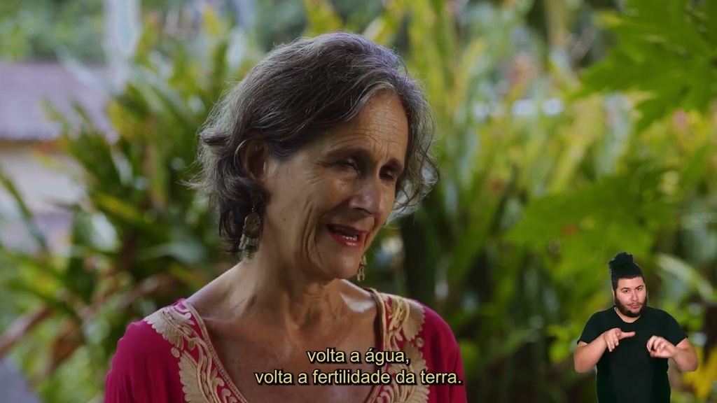
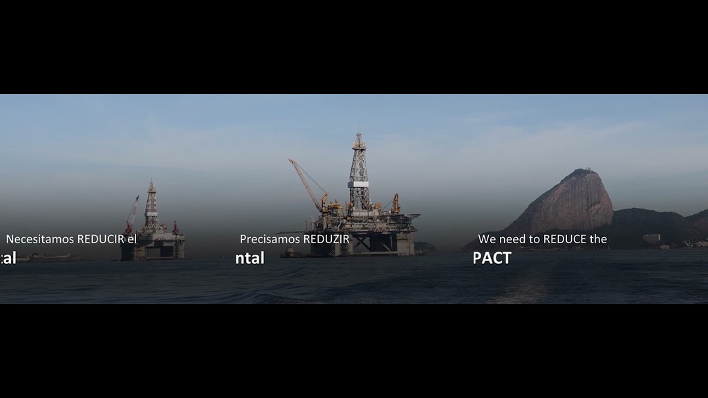
Bays in Motion: Bays are regions of great social and environmental importance. Generally, they are very suitable areas for urban settlement, as they are sheltered coastal environments where a wide variety of ecosystems can be found. However, intense and disordered human occupation results in serious environmental problems that endanger marine life and the balance of an entire region. This is what happened to Guanabara Bay, now surrounded by the second largest metropolitan area in Brazil.
After decades of mistreatment, the bay has accumulated a long list of problems and promises of depollution that have not been fulfilled. However difficult the current scenario may be, nothing would be worse than thinking that it is beyond saving and thus giving up on defending it.
There is much life, beauty, and resilience in Guanabara Bay. And there are many initiatives in favor of its conservation and enhancement. We invite you to navigate this landscape with us and discover its stories, accessing the interactive screens next to the tactile model and using your cell phone to experience augmented reality.
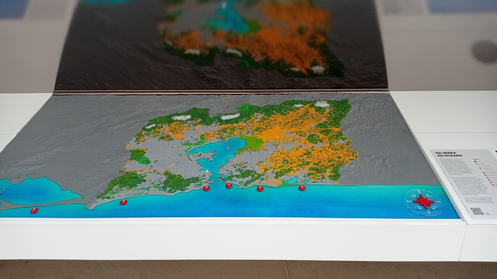
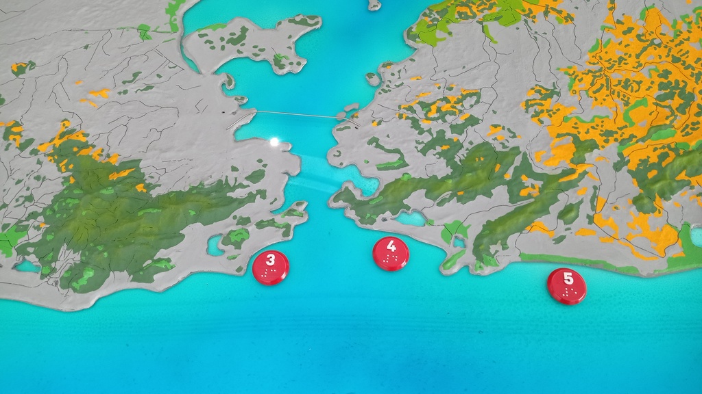
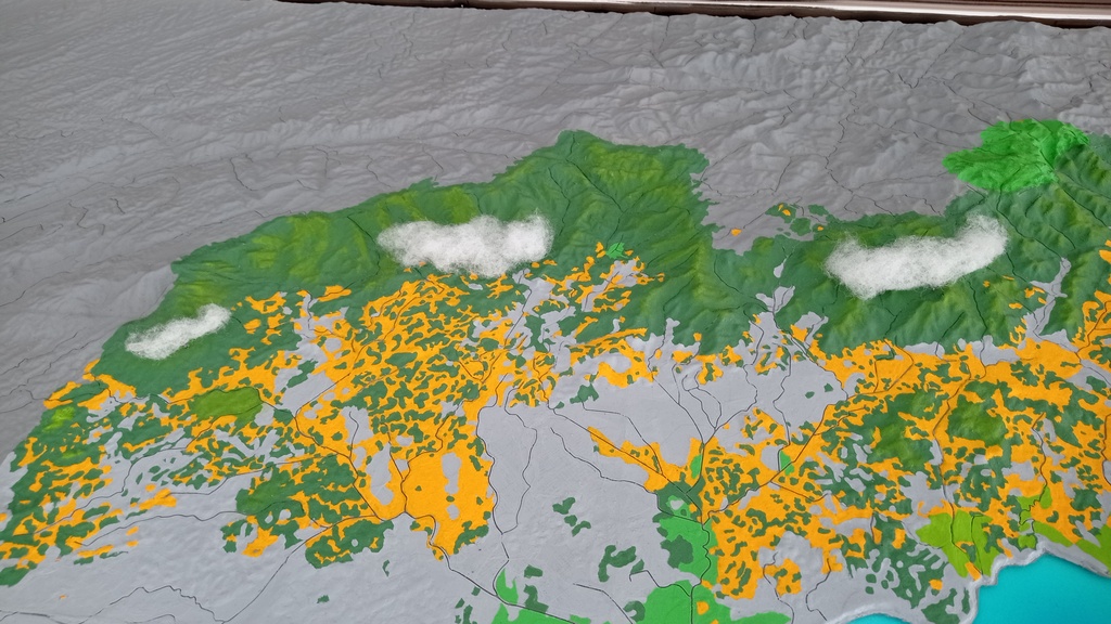
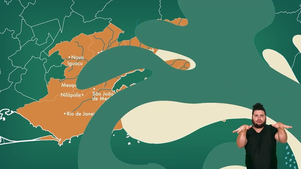
From the mountains to the ocean (braille panel) In an ecosystem, everything is connected in a complex and delicate network. In Guanabara Bay, this involves the connection to the open sea through a channel, which means that half of its waters are renewed every 12 days. It also involves the presence of a mangrove forest, which serves as a nursery for various species. The bay is also affected, of course, by the 17 municipalities and the rivers in its surroundings. Check out the bay's hydrographic basin on this tactile map, which covers 480,000 hectares. The rivers in this area pass through forests, pastures, plantations, and cities, and this is reflected in the quality of their waters when they reach the bay. Thus, to conserve it, it is necessary to care for this entire environment and its population.
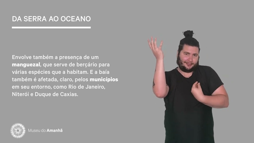
From the mountains to the ocean: In an ecosystem, everything is connected in a complex and delicate network of interactions. In Guanabara Bay, this involves the connection to the open sea through a channel, which causes half of its waters to be naturally renewed every 12 days. It also involves the presence of a mangrove forest, which serves as a nursery for various species that inhabit it. And the bay is also affected, of course, by the municipalities surrounding it, such as Rio de Janeiro, Niterói, and Duque de Caxias.
But it goes further: several rivers from different points flow into the bay, forming the Guanabara Bay hydrographic basin. This territory encompasses 17 municipalities and occupies 480,000 hectares (equivalent to 480,000 football fields).
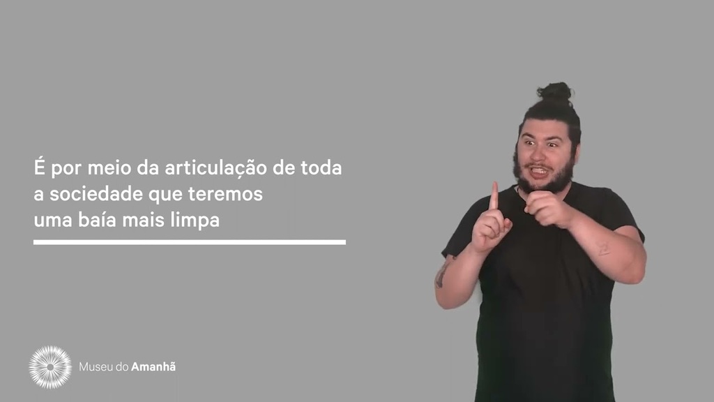
When observing the region's topography, note the course of the main rivers, which cross diverse landscapes: forests, urban areas, pastures, and plantations. Use your cell phone to access an Augmented Reality experience that provides more information about the cultural and environmental richness of this region. Conserving Guanabara Bay involves caring for this entire environment and its population, in a network of collaborations that needs to connect the whole of society.
Captions:
DARK GREEN SQUARE Forest
LIGHT GREEN SQUARE Mangrove
YELLOW SQUARE Pastures and plantations
GRAY SQUARE Urbanized areas
LIGHT POINT Museum of Tomorrow
[QR CODE] English / Español Augmented reality Augmented reality
Beach captions:
. Restinga da Marambaia
2. Barra da Tijuca Beach
3. Copacabana Beach
4. Piratininga Beach
5. Itaipuaçu Beach
6. Maricá-Guarapina Lagoon System
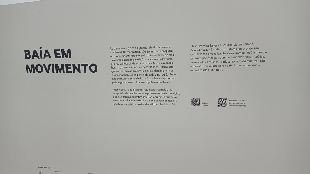
Baía em Movimento As baías são regiões de grande relevância social e ambiental. De modo geral, são áreas muito propícias ao assentamento urbano, pois trata-se de ambientes costeiros abrigados, onde é possível encontrar uma grande variedade de ecossistemas. Mas a ocupação humana, quando intensa e desordenada, resulta em graves problemas ambientais, que colocam em risco a vida marinha e o equilíbrio de toda uma região. Foi o que aconteceu com a baía de Guanabara, hoje cercada pela segunda maior área metropolitana do Brasil.
Após décadas de maus-tratos, a baía acumula uma longa lista de problemas e de promessas de despoluição, que não foram concretizadas. Por mais difícil que seja o cenário atual, nada seria pior do que acharmos que ela não tem mais jeito e, assim, desistirmos de defendê-la.
Há muita vida, beleza e resistência na baía de Guanabara. E há muitas iniciativas em prol de sua conservação e valorização. Convidamos você a navegar conosco por essa paisagem e conhecer suas histórias, acessando as telas interativas ao lado da maquete tátil e usando seu celular para conferir uma experiência em realidade aumentada.
Da Serra ao oceano (painel braille) Em um ecossistema, tudo se conecta, numa rede complexa e delicada. Na Baía de Guanabara, isso envolve a conexão com o mar aberto, por meio de um canal, o que faz com que metade de suas águas sejam renovadas a cada 12 dias. Envolve também a presença de um manguezal, que serve de berçário para várias espécies. A baía também é afetada, claro, pelos 17 municípios e pelos rios de seu entorno. Confira neste mapa tátil a bacia hidrográfica da Baía, que tem 480 mil hectares. Os rios presentes nessa área passam por florestas, pastos, plantações e cidades, e isso se reflete na qualidade de suas águas quando chegam à baía. Assim, para conservá-la, é preciso cuidar de todo esse ambiente e de sua população.
Da serra ao oceano Em um ecossistema, tudo se conecta, numa rede complexa e delicada de interações. Na baía de Guanabara, isso envolve a conexão com o mar aberto, por meio de um canal, o que faz com que metade de suas águas se renovem naturalmente a cada 12 dias. Envolve também a presença de um manguezal, que serve de berçário para várias espécies que nela habitam. E a baía também é afetada, claro, pelos municípios em seu entorno, como Rio de Janeiro, Niterói e Duque de Caxias.
Mas vai além: na baía, desaguam vários rios que vêm de diferentes pontos e formam a bacia hidrográfica da baía de Guanabara. Esse território abrange 17 municípios e ocupa 480 mil hectares (o que equivale a 480 mil campos de futebol).
Ao conferir o relevo da região, observe o curso dos principais rios, que atravessam diversas paisagens: florestas, zonas urbanas, pastos e plantações. Utilize seu celular para acessar uma experiência em Realidade Aumentada, que traz mais informações sobre a riqueza cultural e ambiental dessa região. Conservar a baía de Guanabara envolve cuidar de todo esse ambiente e de sua população, numa rede de articulações que precisa conectar toda a sociedade.
Legendas:
QUADRADO VERDE ESCURO Mata
QUADRADO VERDE CLARO Manguezal
QUADRADO AMARELO Pastos e plantações
QUADRADO CINZA Zonas urbanizadas
PONTO DE LUZ Museu do Amanhã
[QR CODE] English / Español
Realidade aumentada
Augmented reality
Realidad aumentada
Legendas das praias:
1. Restinga da Marambaia
2. Praia da Barra da Tijuca
3. Praia de Copacabana
4. Praia de Piratininga
5. Praia de Itaipuaçu
6. Sistema Lagunar de Maricá-Guarapina
Keyword
BiomesThing
CommunitiesThing
EcologyThing
EcosystemsThing
GeotourismThing
GeographyThing
FaunaThing
FloraThing
Video9